Shipborne Automatic Identification System (AIS)
What is AIS?
AIS is included in the Safety of Life at Sea (SOLAS) Convention, and large ships began fitting AIS in July 2002. AIS transmits, automatically and at set intervals, dynamic information relating to the ship’s course, speed and heading; static information related to the ship’s name, length, breadth; and voyage-related details such as cargo information and navigational status (e.g. underway or at anchor).
Put simply, the Automatic Identification System (AIS) is a Very High Frequency (VHF) radio broadcasting system that transfers packets of data over the VHF data link (VDL) and enables AIS-equipped vessels and shore-based stations to send and receive identification information that can be displayed on a computer or chart plotter.
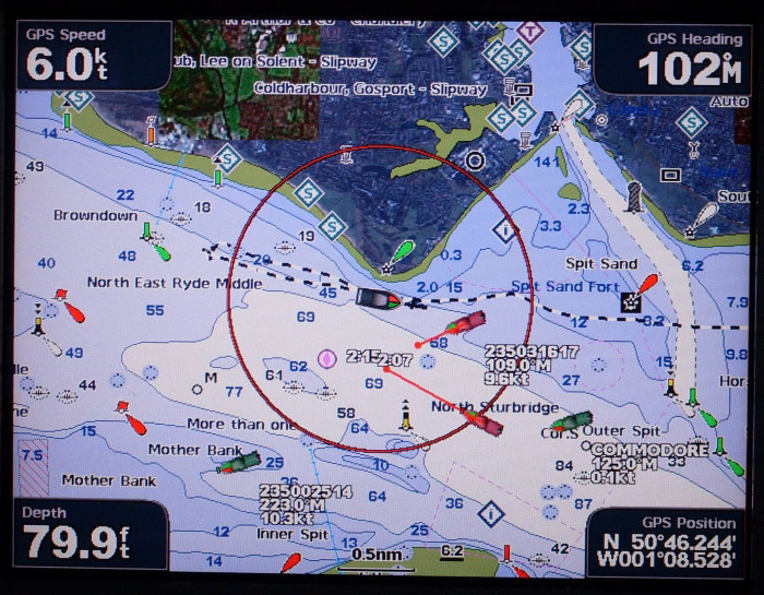
Especially when used with appropriate graphical displays, this information can help in situational awareness and provide a means to assist in collision avoidance. AIS transceivers can be found interfaced to radars and ECDIS (Electronic Chart Display and Information System) displays. When interfaced to a radar, AIS can be a source of target information, in addition to conventional ARPA (Automatic Radar Plotting Aid). AIS fitted to real (physical) aids to navigation such as floating buoys and beacons. AIS base stations can broadcast a non-physical “synthetic” AIS AtoN to appear at the location of a real (physical) AtoN on an AIS-enabled display system (e.g. AIS, ECDIS or radar). AIS base stations can also broadcast a non-physical “virtual” AIS AtoN at a particular location when no real (physical) AtoN exists.
Although AIS is not part of the GMDSS, it can be considered part of the GMDSS due to the advent of the AIS-SART (AIS Search and Rescue Transmitter), which can be used in lieu of a search and rescue radar transponder (SART), since 01 January 2010. AIS transceivers on ships also have a simple text communications capability called Short Safety- related Messaging (SSRM), but does not constitute a distress- alerting system, and uses the VHF maritime mobile band.
System description
Each AIS station consists of one VHF transmitter, two VHF receivers (AIS 1 and AIS 2), one VHF DSC receiver (CH.70), a standard marine electronic communications link and sensor systems. Timing and positional information comes from a Global Navigation Satellite System (GNSS) receiver.
Types and classes of AIS
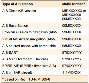
There are two classes of shipborne AIS – Class A and Class B. In addition, there are different types of AIS used for shore stations (AIS Base Stations), AIS aids to navigation (AIS AtoN), AIS on search and rescue aircraft and the AIS search and rescue transmitter (AIS- SART).
AIS Class A – Class A has been mandated by the International Maritime Organization (IMO) for vessels of 300 gross tonnage and upwards engaged on international voyages, cargo ships of 500 gross tonnage and upwards not engaged on international voyages, as well as passenger ships (more than 12 passengers), irrespective of size.
AIS Class b – Class B provides limited functionality and is intended for non-SOLAS vessels. It is not mandated by the International Maritime Organization (IMO) and has been developed for vessels such as work craft and pleasure craft.
AIS base Station – Base stations are provided by an aids to navigation authority to enable the ship- to-shore/shore-to-ship transmission of information. Networked AIS Base Stations can assist in providing overall maritime domain awareness.
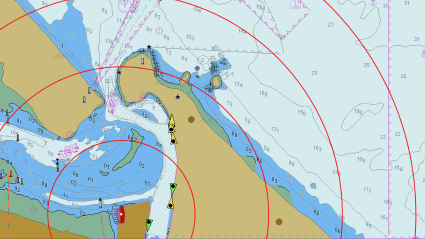
AIS Aids to Navigation (AtoN) – AIS AtoN provide an opportunity to transmit position and status of buoys and lights through the same VDL, which can then show up on the electronic chart or computer display.
AIS-SART – Search and Rescue Transmitters using AIS can be used to assist in determining the final locating of a vessel or life raft, as part of the Global Maritime Distress and Safety System (GMDSS).
AIS on Search and Rescue (SAR) Aircraft – Search and rescue Aircraft may use AIS to assist in their operations.
How AIS works
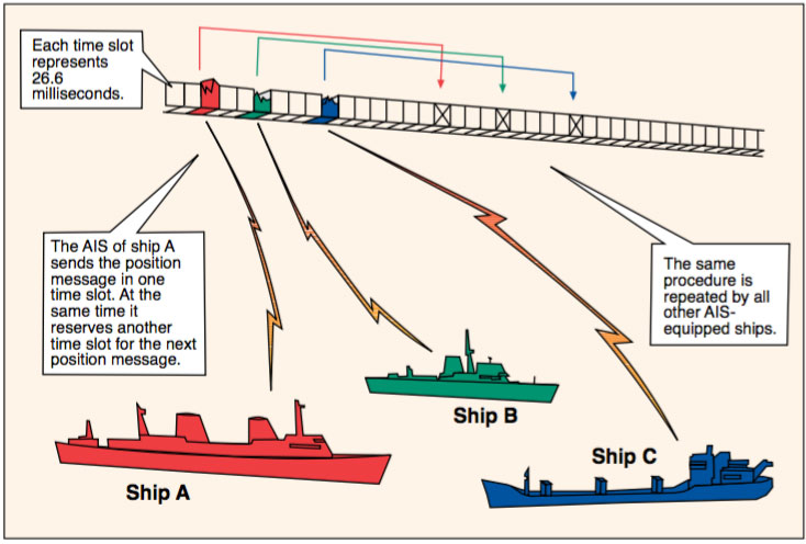
AIS works in an autonomous and continuous mode, no matter where the vessel is located – the high seas, coastal waters or inland waterways. AIS uses a time-division multiple access (TDMA) scheme to share the VHF frequency, also known as the VHF Data Link (VDL).
There are two dedicated frequencies used for AIS: AIS 1(161.975 MHz, previously known as channel 87B) and AIS 2 (162.025 MHz, previously known as channel 88B). Each frequency of the VDL is divided into 2250 time slots that are repeated every 60 s, and the AIS units send packets of information which are transmitted on these slots. At the same time, every AIS vessel in range is listening to the timeslots, and can receive the information.
For example, the system operates by a ship determining its geographical position with an Electronic Position Fixing Device which is fed into the AIS (or, in the case of AIS Class B, integral to the AIS unit). The AIS station then transmits this position, combined with ship identity and other ship data via the VHF radio link to other AIS-equipped ships and AIS base stations that are within radio range. In a similar fashion, the ship when not transmitting, receives corresponding information from all ships and base stations that are within radio range. The content of what is transmitted is determined by the message type. At present there are 25 identified AIS message types.
There are different technical means of transmitting in these slots. AIS Class A uses a self-organized approach (STDMA or SOTDMA) while AIS Class B units may use a carrier-sense approach (CSTDMA) as well as SOTDMA. Base stations use fixed slots (known as FATDMA) while AIS Aids to Navigation have an option to use FATDMA or a random access process called RATDMA, depending on the type of unit.
Messages are packed in slots that are accurately synchronised using GNSS timing information. Each station determines its own transmission schedule (slot), based upon data link traffic history and knowledge of future actions by other stations. A position report from one AIS station fits into one of 2250 time slots established every 60 s.
Functionality and capability
The IMO Performance Standard for AIS requires that the system should be capable of operating:
• In the ship–to–ship mode, to assist in collision avoidance;
• As a means for littoral States to obtain information about a ship and its cargo; and
• As a VTS tool, i.e. ship–to–shore (traffic management).
This functionality is further expanded in the Performance Standard to require the capability of:
• Operating in a number of modes:
- An “autonomous and continuous” mode for operation in all areas. This mode should be capable of being switched to/from one of the following alternate modes by a competent authority;
- An “assigned” mode for operation in an area subject to a competent authority responsible for tra c monitoring such that the data transmission interval and/or time slots may be set remotely by that authority; and
- A “polling” or controlled mode where the data transfer occurs in response to interrogation from a ship or competent authority.
• Providing information automatically and continuously to a competent authority and other ships, without involvement of ship’s personnel;
• Receiving and processing information from other sources, including from a competent authority and from other ships;
• Responding to high priority and safety related calls with a minimum of delay; and
• Providing positional and manoeuvring information at a data rate adequate to facilitate accurate tracking by a competent authority and other ships.
Main component parts of a Class A shipborne AIS station
GNSS receiver – A GNSS receiver supplies the time reference to the AIS station to ensure all transmissions are synchronized. VHF Transmitter/Receiver – There is one VHF transmitter and two VHF receivers for TDMA operation. The VHF transmits and receives the radio signals that form the data links that interconnect the AIS station to each other. Data is transmitted and received in short time slots (26.76 ms) by the VHF radio.
DSC VHF receiver – The DSC receiver is fixed to channel 70 to receive channel management commands for regional area designation. The DSC receiver can also be used for limited DSC polling. When replying to DSC polling, the common VHF transmitter is used.
AIS VHF Antenna - is a vertical polarized omni-directional antenna, and its location is critical to the success of the installation. The antenna should be installed away from interfering high power energy sources like radar and other antennas, and be located so that its omni-directional properties are not impeded. Likewise the connecting cable should be kept as short as possible to minimize attenuation of the signal.
Controller – The control unit is the central intelligence of the AIS station. It manages the time slot selection process, the operation of the transmitters and receivers, the processing of the various input signals and the subsequent distribution of all of the output and input signals to the various interface plugs and sockets, and the processing of messages into suitable transmission packets.
built in Integrity Test (bIIT) – the BITT controls continuously integrity and the operation of the unit. This runs continuously, and if any failure or malfunction is detected that will significantly reduce integrity or stop operation of the AIS, an alarm is initiated. In this case the alarm is displayed on the minimum keyboard and display (MKD) unit and the alarm relay is set “active”. The alarm relay is deactivated upon acknowledgement either internally by means of minimum display and keyboard or externally by a corresponding acknowledgement sentence.
Signal Interface Connectors – In order to be able to transmit all the information included in a position report, the AIS station has to collect information from various ship sensors. There are also interfaces for connection to external display systems.
Minimum Keyboard and Display (MKD) – an MKD unit is mandatory on Class A mobile stations: The MKD has the following functions:
• Configures and operates the equipment;
• Shows as a minimum three lines of information;
• Inputs all data via an alphanumerical keyboard;
• Displays all received vessels bearing, range and names; and
• Indicates alarm conditions and means to view and acknowledge the alarm.
The MKD has a wider application, which may be used to input voyage-related data, i.e. cargo category, maximum present static draught, number of persons onboard, ETA and navigational status.
• Input static information such as:
– MMSI number;
– IMO number; and
– Ship’s callsign, name, length and beam.
• Display safety-related messages;
• and Input safety-related messages
Messages and type formats
AIS employs the principle of using a ship’s speed and manoeuvring status as a means of governing information update rates and ensuring the appropriate levels of positional accuracy for ship tracking. This is shown in Table 3. A similar process is applied to the content of ship information messages to ensure that the data being transferred is not encumbered with static or low priority information.
The different information types, identified as “static”, “dynamic” or “voyage-related” are valid for a different time periods and thus require a different update rate.
Information in the various message types includes:
• Static information: Every 6 min and on request:
– MMSI;
– IMO number (where available);
– Call sign & name;
– Length and beam;
– Type of ship; and
– Location of the position– fixing antenna on the ship (aft of bow/port or starboard of centreline).
- Dynamic information: Dependant on speed and course alteration
– Ship’s position with accuracy indication and integrity status;
– Position time stamp (in UTC);
– Course over ground (COG);
– Speed over ground (SOG);
– Heading;
– Navigational status (e.g. at anchor, underway, aground, etc. – this is input manually); and
– Rate of turn (where available).
- Voyage–related information: Every 6 min, when data is amended, or on request – Ship’s draught; – Hazardous cargo (type); – Destination and ETA (at master’s discretion); and – Route plan (waypoints).
- Short safety–related messages;
– Free–format text message – sent as required.
Display requirements
If there is navigational equipment capable of processing and displaying AIS information such as ECDIS, radar or an integrated system, then the AIS Class A mobile system may be connected to that system via the AIS Presentation Interface (PI). The PI (input/output) needs to meet the requirements of relevant IEC standards (latest edition of IEC 61162). At present, there are a number of AIS units that use the Minimum Keyboard Display (MKD) which provides text based or basic graphic display elements.
The revised IMO radar performance standards (IMO Resolution MSC.192(79) 2004), states that all new radars fitted to ships after July 2008 must be able to display AIS targets. As AIS will be displayed on radar, and may also be displayed on Electronic Chart Display and Information Systems (ECDIS), it is unlikely that the MKD will evolve, and it is more likely that radar and ECDIS will be used to display AIS data.
Benefits and errors of AIS
AIS has many benefits that can assist in enhancing situational awareness and supporting safety of navigation and protection of the environment both ashore and a oat. These include:
• Range and ability to ‘see’ around corners – AIS uses the VHF band, which is not restricted to line- of-sight operation;
• Information on course and intentions of other vessels – AIS provides heading of a vessel, which may be di cult to assess by radar or other means and can also provide rapid indication in change of heading or course;
• Extended data fields – the static and voyage-related data can help clarify intentions, although this could also be misleading if data is not up to date;
• Identification of vessels – AIS provides a name/call sign / MMSI to assist with positive identification of another vessel;
• DGPS corrections – these may be transmitted from an AIS Base Station over the VDL;
• Short safety related messages (SSRM) – capability to send and receive short text messages related to safety matters, i.e. bridge-bridge communication or shore-to-ship messaging (but not a distress alerting mechanism). SSRMs can be addressed to an individual station or to all ships. They content of these messages is intended to relate to the safety of navigation (e.g. the sighting of an iceberg or a buoy not on station). The maximum length of a single message is 162 characters, but they should be kept as short as possible to reduce the load on the VDL. Great care must be taken to avoid relying on such messages when a close quarters situation is developing, since there is no guarantee that receiving vessels will be able to readily display such messages.
• Application-Specific Messages (formerly known as Binary Messages) – these provide a data communications mechanism suitable for computer systems that may be connected to an AIS transceiver aboard a ship (such as an ECDIS) or from AIS aids to navigation, or from AIS base station. AIS Application- Specific Messages can be addressed or broadcast.
From 2004, for four years (as described in SN/Circ.236), seven messages were trialled for international use, meteorological and hydrological data, dangerous cargo, fairway closed, tidal window, extended ship state and voyage-related data, number of persons on board and AIS target (virtual).
In 2010, the IMO decided to revoke SN/Circ.236 as from 1 January 2013, and replace it with SN.1/Circ.289, which has 14 messages as follows: meteorological and hydrological data, dangerous cargo, tidal window, extended ship static and voyage-related data, number of persons on board, VTS-generated/Synthetic targets, clearance time to enter port, marine traffic signal, berthing data, weather observation from ship, area notice, environmental, route information and text description. Within each of these messages a large amount of data can be encoded.
There are also a number of common errors and drawbacks of AIS:
- It is common to see incorrect data entry in some AIS data fields which are manually inserted by the ship, or incorrectly programmed at installation or during maintenance. These fields are called the voyage-related and static data fields;
- AIS relies on vessels using an accurate (or at least common) source of positional data that will fail if that positioning system fails (i.e. GNSS; datum); and
- Display systems using only the MKD are quite limited, and AIS may not be used to full advantage. It is also important to remember that not all ships carry AIS, especially other non-SOLAS work craft or pleasure craft, and warships (at their discretion to t and use). Also, as noted in the IMO resolution, it is possible that a Master of a vessel may have turned o the AIS if he/ she considers it essential for the safety of the vessel.
Contribution of AIS
The AIS station, with its ability to exchange large blocks of information at high data rates, offers a new tool to enhance the safety of navigation and efficiency of shipping traffic management. In the ship-to- ship mode AIS is being used to assist in situational awareness and as another tool to aid in collision avoidance.
Coastal ship reporting systems, VTS and ports are significant beneficiaries of this wealth of near real time ship data, with many countries implementing AIS base station coverage in an integrated manner for vessel tracking. The AIS data transfer also provides the means for a wide range of maritime regulatory, traffic monitoring, administrative and logistical management activities that can be exploited to advantage by the maritime industry. The IMO Guidelines for the Onboard Operational Use of Shipborne AIS, IMO Assembly Resolution A22/ Res.917 are also listed in Appendix 8.


Be the first to comment