Emergency Position Indicating Radio Beacons
EPIRB is one of three main types of radio beacons that are used in emergency situations for search and rescue.
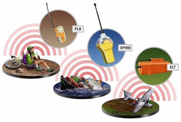
- EPIRBs (Emergency Position Indicating Radio Beacons) for maritime use
- ELTs (Emergency Locator Transmitters) for aviation use
- PLBs (Personal Locator Beacons) for personal use (in a remote environment)
All of them - EPIRBs, ELTs and PLBs - operate within a satellite-based system at a frequency of 406 megahertz. This frequency has been designated internationally for use only in distress.
Also, emergency beacons should be equipped with a 121.5 MHz radio transmitter. A low-power 121.5 MHz homing signal is used to guide rescue services when they are within 10 miles away from the beacon.

An activated distress beacon transmits on the frequencies 406.025 MHz (digital signal) and 121.5 MHz (analogue homing signal). Channel 121.5 MHz is not detected by satellites. Photo by ACR Electronics and Ocean Signal
What is a 406 MHz EPIRB
The EPIRB is a digital 406 MHz radio transmitter that can be activated in life-threatening situations to request assistance from the authorities responsible for search and rescue operations. After activation, it will work for at least 48 hours.
In many ways, the principle of operation of the 406 MHz EPIRB is similar to the principles of functioning of all 406 MHz beacons, but it also has its own specific features.
As mentioned above, this type of beacon is designed for maritime purposes. The device sends a signal that helps to detect and locate a vessel in distress.
EPIRBs are a component of the GMDSS, as well as a key element of Cospas-Sarsat.

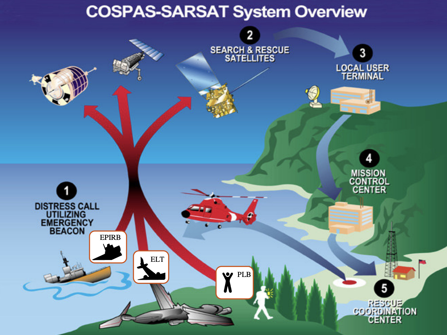
This international satellite-based system detects and locates emergency beacons activated by aircraft, ships and persons in distress, and forwards this alert information to search and rescue (SAR) authorities. In plain words, Cospas-Sarsat performs the "search" function for "search and rescue" activities.
Emergency beacons as part of Cospas-Sarsat
When a distress beacon is activated, the Cospas-Sarsat system:
-
decodes the binary coded message of the beacon that contains information such as the ship or aircraft identification number and the location of the beacon (for beacons equipped with GNSS receivers);
-
performs a mathematical analysis of the signal to calculate the location of the beacon, even if its location is not specified in the distress message.
The services of the system are free for users all over the world.
Cospas-Sarsat uses several types of satellite systems, which calculate the location of the beacon by various methods with different degrees of accuracy.
The primary means of calculating coordinates is the Doppler shift method. The positioning accuracy when using it is up to 2 km.
The functioning of “regular” or "traditional" 406 MHz EPIRBs is based on this method. Providing assistance in this case is assigned to the coastal authorities, who will relay the information about the location of the activated beacon to the rescue ships. The rescue ships will carry out search and rescue operations on scene.
GNSS positioning is used as a second reference for location.
GNSS/GPS EPIRBs
All modern EPIRBs are equipped with GNSS receivers that provide integration with Global Navigation Satellite Systems. The GNSS receiver allows the beacon to transmit its location along with the 406 MHz satellite signal. In fact, GNSS/GPS EPIRB is an upgrade over the traditional EPIRB.
Thanks to the technology used, the position of the EPIRB is detected with an accuracy of 100 m, which greatly facilitates positioning.
AIS EPIRBs
The newly approved EPIRBs have an integrated AIS transmitter.
In turn, such AIS EPIRB is an upgrade over a GNSS/GPS EPIRB. Each AIS EPIRB has a built-in GNSS receiver.
When an EPIRB with AIS is activated, an AIS signal is sent to nearby vessels equipped with an AIS transponder, which are then instantly notified of the ship in distress and its location. Location data is provided using GNSS technology.
Thus, rescue operations can be carried out in a faster way: rescue vessels can locate the beacon electronically, without needing the position to be relayed from the shore.
Besides it, AIS EPIRBs can send signals to other vessels directly, before the coastal services detect the distress.
New EPIRB requirements for SOLAS vessels
According to MSC.471(101) Annex 24, every float free EPIRB installed on or after July 1, 2022, must have the internal AIS frequency along with the 406 MHz channel and the GNSS receiver. And, of course, the 121.5 MHz transmitter.
If an EPIRB is installed on a ship before this date, it may not comply with these regulations.
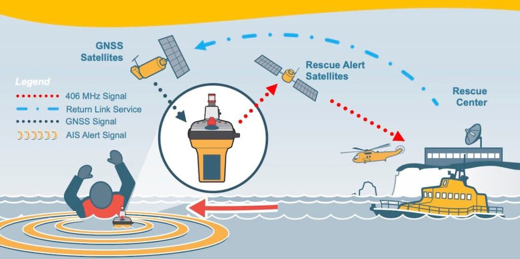
RLS-enabled EPIRBs
Some new beacon models are also equipped with Return Link Service feature by Galileo.
RLS messages (light indication or text on the beacon display) confirm to the user that the distress signal from his beacon was received by the SAR authorities.
RLS-enabled beacon operation
However, let's get back to the Cospas-Sarsat system and see how it functions. This will help us understand what role EPIRBs and other types of beacons play inside it and what they will be, the EPIRBs of the future.
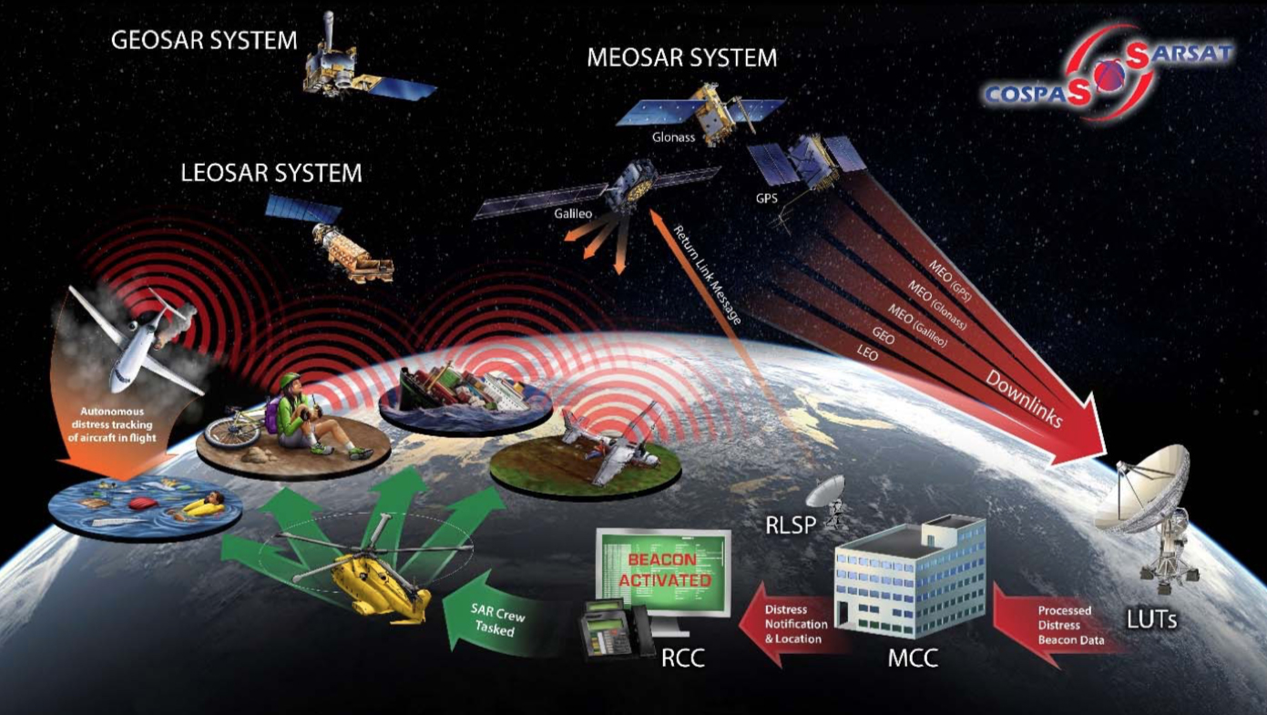
Cospas-Sarsat system operation
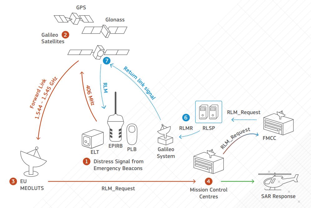
The Cospas-Sarsat system consists of a space segment and a ground infrastructure, which include:
- Distress beacons transmitting 406 MHz signals which are received by SAR instruments installed on spacecraft used by the system;
- Search and rescue instruments placed on board the satellite - SARR (SAR signal repeaters) and SARP (SAR signal processors); they process and/or relay the emergency beacon signal to the nearest available ground station;
- LUTs (local user terminals) - ground receiving stations that process the satellite downlink signals to extract the beacon identification data and produce an independent determination of the beacon location;
- MCCs (mission control centers) that obtain the output data generated by LUTs and send message about an emergency and its location to the appropriate search and rescue authority;
- RCCs (rescue coordination centers) - authorities responsible for carrying out the necessary search and rescue operations.
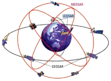
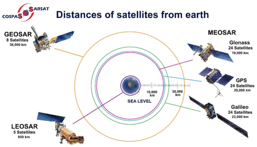
Until recently, the Cospas-Sarsat system has been integrated with two types of satellites:
-
satellites in relatively low (800-900 km) polar orbits that form the LEOSAR system (Low Earth Orbit Search And Rescue);
-
satellites in equatorial fixed orbits at an altitude of 36,000 km that form the GEOSAR system (Geostationary Earth Orbit Search And Rescue).
In last years, the Cospas-Sarsat system is in a state of large scale modernization - SAR repeaters are been installed on board of GNSS (Global Navigation Satellite System) satellites orbiting the Earth at an altitude of 19 to 23 thousand km: GPS (United States), Galileo (European Union), and GLONASS (Russia).
These new Cospas-Sarsat space elements form a system called MEOSAR (Medium Earth Orbit Search And Rescue).
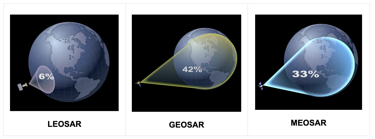
Each satellite system is located at a different altitude and has a different field of view. Consequently, they all have a different capacity to detect the beacon signals.
For example, GEOSAR satellites have the widest coverage of the Earth's surface, but they are significantly further from it than LEOSAR and MEOSAR satellites, so the quality of the received signal is not as good.
According to C/S G.003 - INTRODUCTION TO THE COSPAS-SARSAT SYSTEM, the key performance parameters that the Cospas-Sarsat system should meet are as follows:
- Global coverage
- Automatic beacon activation
- Timely alerting
- Beacon location accuracy
Not all of the space segments that are part of Cospas-Sarsat fully meet these parameters.
For example, the GEOSAR system provides coverage for detecting 406 MHz beacons in all parts of the Earth between 75° South latitude and 75° North latitude, excluding the pole zone. These gaps around the poles cannot be eliminated due to the nature of the geostationary orbits.
Other space systems (LEOSAR or MEOSAR) do not have a similar restriction.
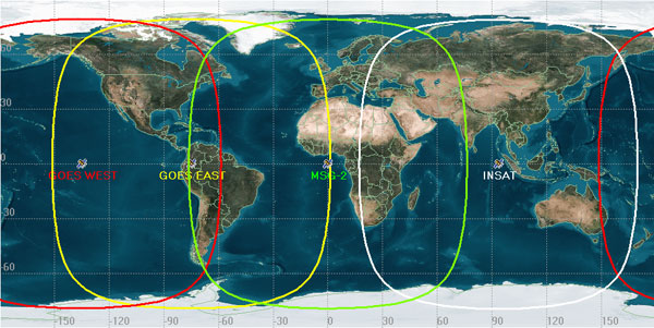
GEOSAR coverage areas: all parts of the Earth between 75° South and 75° North, excluding the pole zone. LEOSAR and MEOSAR: global coverage
As for the alert timing criteria, it is as follows: the distress alert must be transmitted to the responsible RCC within 15 minutes after the initial signal from the beacon is received.
The GEOSAR and MEOSAR systems meet and exceed this requirement (provide real-time alerting).
A peculiar feature of the LEOSAR system is that the LEOLUT collects the data during the complete pass of the satellite over the LUT - its orbit period is about 100 minutes. This time interval may be required to compute an independent solution and pass it to the MCC for distribution.
Another critical parameter is the accuracy of determining the beacon location. The solutions used by the LEOSAR system (Doppler processing) and the MEOSAR system (FDOA (frequency difference of arrival) and TDOA (time difference of arrival) techniques) satisfy it.
The nature of GEO satellites does not allow them to be used for independent location, however they can instantly repeat a message with an encoded location that was calculated by a GNSS receiver inside the beacon.
Thus, the MEOSAR system includes all the advantages of both LEOSAR and GEOSAR systems. At the same time, it overcomes their current multiple limitations. When a high level of satellite redundancy and availability is achieved (there will be 72 of them), this system will significantly improve the speed and accuracy of locating emergency beacons. More lives will be saved.
In the coming years, all satellite systems - LEOSAR, GEOSAR and MEOSAR - will operate in tandem, serving both first- and second-generation beacons; their compatibility parameters have been agreed.
Source: https://www.sarsat.noaa.gov
First and second generation Cospas-Sarsat beacons
It is worth saying here that beacons designed to operate with the LEOSAR system are conventionally called first generation beacons (FGB). They are also compatible with the GEOSAR system (C/S T.001 - SPECIFICATION FOR COSPAS-SARSAT 406 MHz DISTRESS BEACONS).
Beacons that are being developed for operating in the Cospas-Sarsat satellite system of a new generation, MEOSAR, are called second generation beacons (SGB). They will also be compatible with the GEOSAR system (C/S T.018 - SPECIFICATION FOR SECOND-GENERATION COSPAS-SARSAT 406 MHz DISTRESS BEACONS).
SGBs will appear on the market in the coming years, they will have expanded functionality and will meet the updated criteria for the Cospas-Sarsat system.
In the future, Cospas-Sarsat will rely on a MEO/GEO space segment. The MEOSAR system will replace the LEOSAR system and become the dominant space segment of Cospas-Sarsat. This system will pinpoint the location of the beacon in close to real time with a high degree of accuracy that is not available in the current system.
At the beginning of 2023, the second-generation beacons have not yet appeared on the market, but it is a matter of a short time, it is quite obvious.
Therefore, in our article, when talking about EPIRBs, we mean beacons of the first generation.
EPIRB categories. EPIRB activation
EPIRBs are divided into 2 categories depending on the features of their bracket and the conditions of their activation.
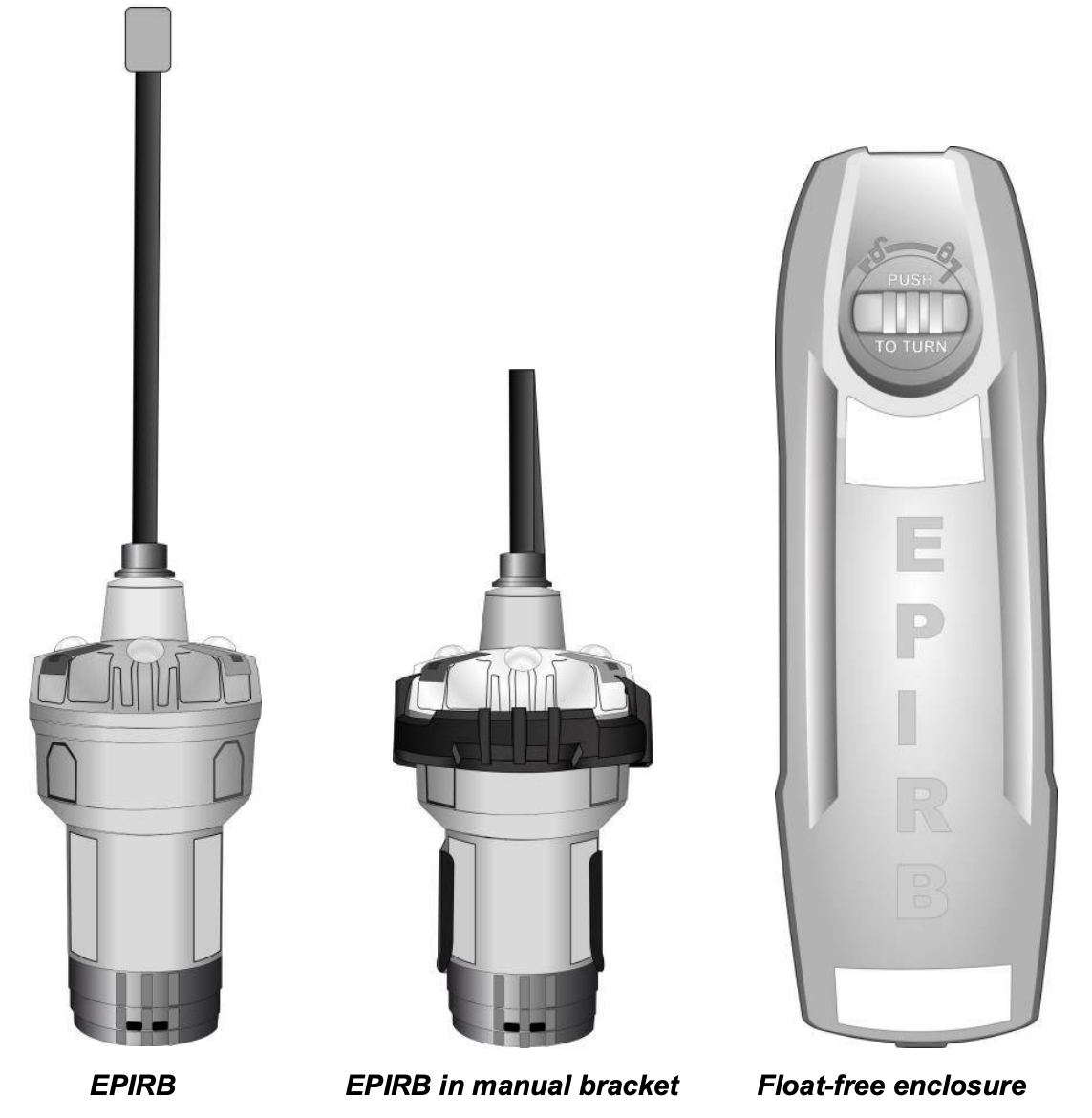
EPIRBs of the first category are activated automatically. These are float free 406/121.5 MHz EPIRBs, recognized by GMDSS.
Float free EPIRB is intended to float free of the vessel on which it is installed. It is automatically activated if the vessel sinks. Such EPIRB can also be manually activated.
Beacons of this type are housed in a special bracket equipped with a hydrostatic release unit (HRU). Activation is triggered when the EPIRB is released from its bracket. The mechanism releases the EPIRB at a water depth of 1.5-4 meters. Then the EPIRB floats to the surface and starts transmitting an alert signal.
Category I EPIRBs must be installed outside the cabin of the vessel to be able to "float free" from the sinking vessel.
Source: McMurdo EPIRB-AIS User Manual
Category II includes manually activated EPIRBs, or non float free 406/121.5 MHz EPIRBs.
Such EPIRBs should be physically removed from their brackets and then either manually activated or dropped into the water so that it is then activated automatically.
Non float free EPIRB should be stored in a place on board where it can be quickly accessed in an emergency.
All modern EPIRBs provide both methods of activation and deployment.
There are also 3 classes of operating temperature range for 406 MHz EPIRBs:
Class 0: -55°C to +70°C
Class 1: -40°C to +55°C
Class 2: -20°C to +55°C
Beacon HEX ID. Beacon registration
The International Maritime Organization (IMO) regulates the carriage of EPIRBs on ships engaged in international voyages. Many countries apply the same regulations to ships in their own waters.
According to IMO and ICAO regulations, all distress beacons operating on 406 MHz should be registered.
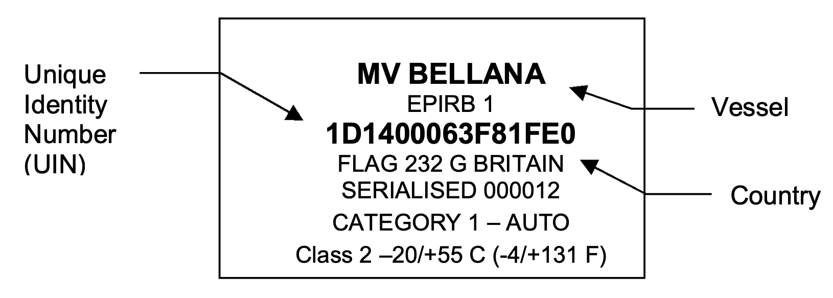
Each 406 MHz beacon has a unique identification number (UIN) that is transmitted as part of its signal. This is a 15-character hexadecimal identifier (HEX ID), which is programmed by the supplier into the beacon before being installed on board the vessel. It is marked on the label affixed to it, as well as on the box it was packed in.
After beacon registration, this HEX ID becomes a unique identifier that allows rescuers to know who they are looking for. Of course, only if the beacon is activated.
The owner should know the identifier of his beacon, as this is the best (and often the only) way to uniquely distinguish his beacon from all others.
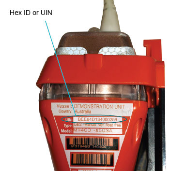
Each 406 beacon has a unique 15-character HEX ID or UIN: [numbers from 0 to 9 and letters from A to F]
The HEX ID code indicates a specific vessel and the country of the EPIRB registration.
LUTs anywhere in the world, receiving a distress alert and geopositioning from an activated 406 MHz EPIRB, can identify a vessel in distress, as well as the country of its registration.
This is a great advantage for search and rescue planning, since each national MRCC (Maritime Rescue Coordination Centre) keeps records of the characteristics of the vessel, such as its description, the number of crew members, etc.
Source: McMurdo EPIRB-AIS User Manual
For the successful operation of the system and for the safety of EPIRB users, it is mandatory that they register their beacons. The registration information should be available to search and rescue authorities.
The IMO Resolution MSC.514(105) GUIDELINES FOR THE AVOIDANCE OF FALSE DISTRESS ALERTS (supersedes resolution A.814(19), as from 1 January 2024) directly states this rule:
“Companies, masters and seafarers should, as appropriate, ensure that…
encoded identities of EPIRBs, which are used by SAR personnel responding to emergencies, are properly registered in a database accessible 24 hours a day or automatically provided to SAR authorities (masters should confirm that their EPIRBs have been registered with such a database, to help SAR services identify the ship in the event of distress and rapidly obtain other information which will enable them to respond appropriately)...”
Purchasers of second-hand 406 MHz EPIRBs are also obliged to provide the details to be added to the database.
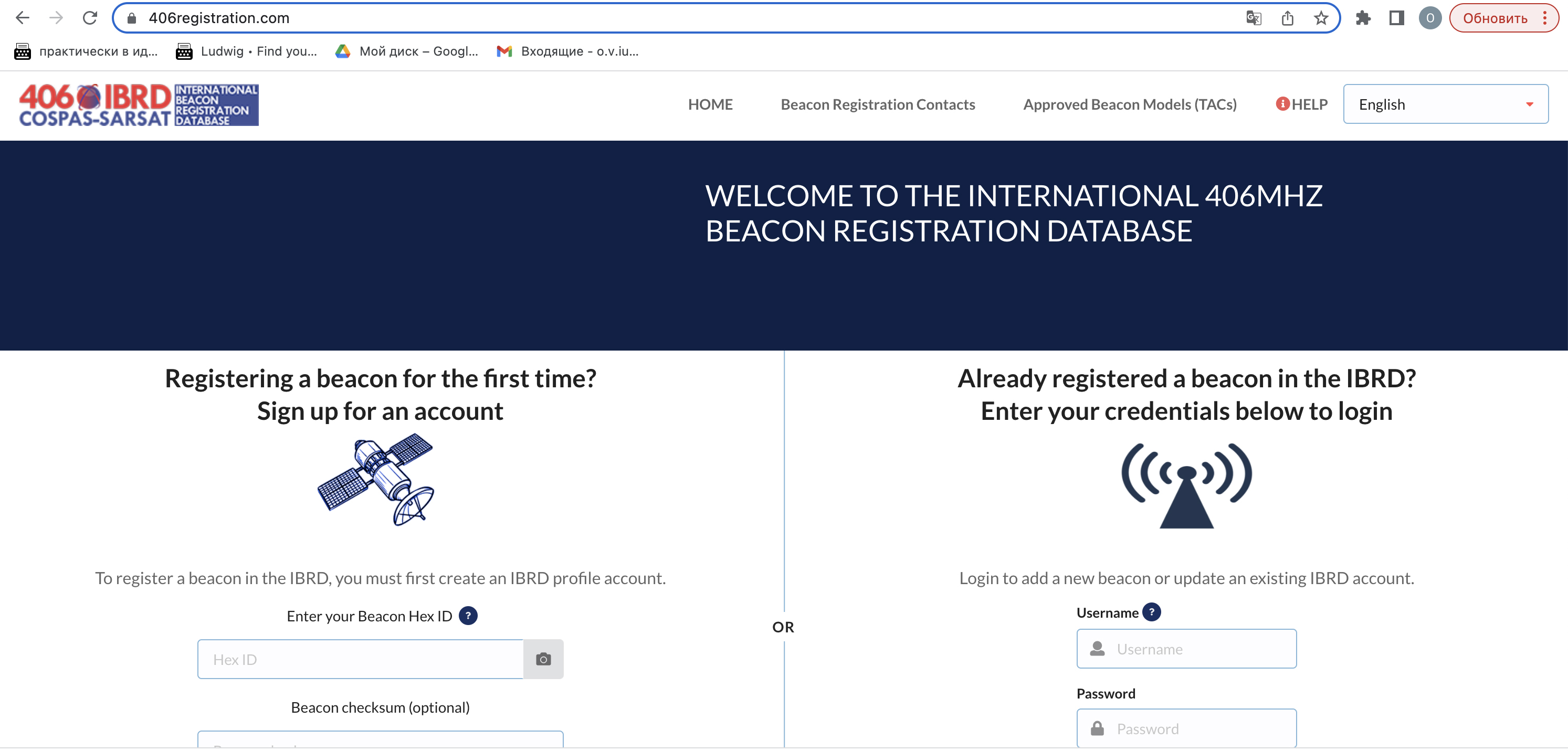
To facilitate access to information on the registration of beacons, Cospas-Sarsat has made available the International 406 MHz Beacon Registration Database. It started functioning on January 16, 2006.
Inadvertent activation of 406 MHz EPIRBs
Every year, valuable resources are wasted to detect the location of EPIRBs that were activated by accident.
Users need to know that even a single burst from a 406 MHz beacon can be instantly detected by the Cospas-Sarsat GEOSAR system, which will result in a RCC being alerted.
False distress alerts cause serious consequences, so their transmission is strictly prohibited.
If for any reason an EPIRB is activated accidentally, the ship should contact the nearest coast station or RCC and cancel the distress alert.
However, no action normally will be taken against shipowners and seafarers for reporting a false alert and canceling it. If such violations are repeated, Governments may prosecute.

More information can be found in IMO Resolution A.814 (19) GUIDELINES FOR THE AVOIDANCE OF FALSE DISTRESS ALERTS (will be superseded by IMO Resolution MSC.514(105) GUIDELINES FOR THE AVOIDANCE OF FALSE DISTRESS ALERTS, as from 1 January 2024).
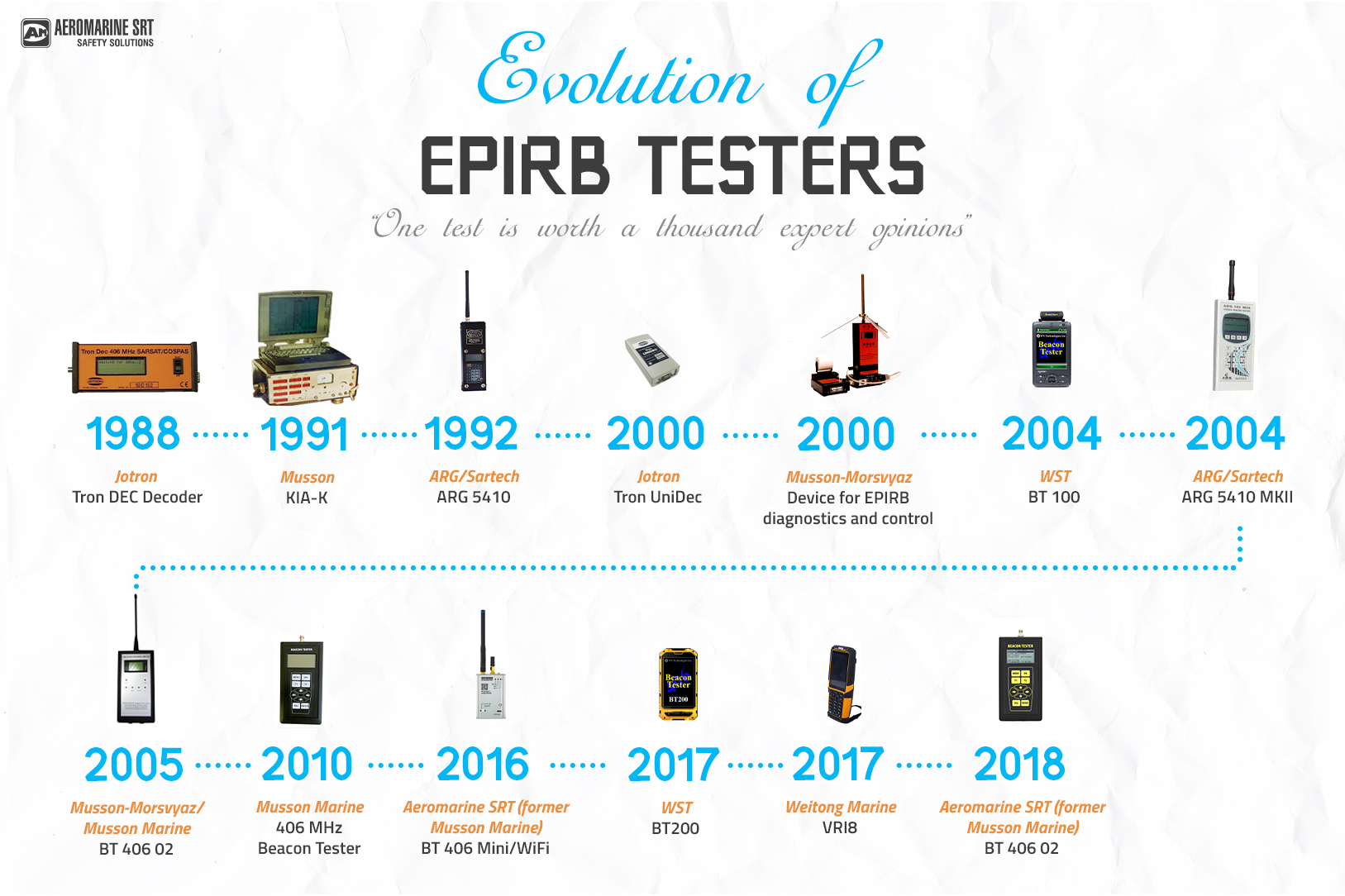
Testing EPIRBs
EPIRBs, as an important part of GMDSS equipment, must work properly to perform the functions assigned to them. To make sure of this, it is regularly tested.
The self-test function of EPIRBs should be checked once a month. It is performed by the ship's GMDSS radio operator. This self-test confirms that the distress transmitters and GPS receiver are functional, the battery is healthy, and the strobe light is operational. The beacons and their mountings are also to be examined for physical damage. It is necessary to check the expiration date of the battery and the condition of the HRU (hydrostatic release unit), to check for the lanyard and the conditions of contact with seawater.
EPIRBs are also subject to annual performance tests and shore-based maintenance. They are mandatory for those vessels that are subject to GMDSS regulations.
The inspections are performed by qualified specialists - radio surveyors. During such inspections, the surveyors carry out a thorough check of the operability of EPIRB with the help of professional GMDSS testers.
By Olga Davydova


Be the first to comment