GMDSS Satellite Service Providers: China’s BeiDou coming soon
Global Maritime Distress and Safety System (GMDSS) is a worldwide system that provides critical communication in emergency situations. The strictest selection is carried out for all service providers for this system, including satellite ones. Numerous assessments and checks aim to confirm that satellite services are provided at an appropriate high level and meet the criteria set out in IMO resolution A. 1001(25) on Criteria for the Provision of the Satellite Communication Systems in the GMDSS.
For many years, the only provider of satellite GMDSS services was Inmarsat. In 2020, its monopoly was broken up - Iridium was successfully approved by the IMO, Iridium GMDSS has become a powerful alternative to Inmarsat GMDSS, covering all GMDSS sea areas from A1 to A4 and offering a built-in Safety Voice Service.
In the near future, there may be even more players in this field: in 2018, the Chinese BeiDou applied for recognition as a GMDSS service provider. If the assessment process is successful, BeiDou will become the third provider of satellite services for GMDSS, along with Inmarsat and Iridium. GMDSS will therefore make the transition to a multi-provider environment.
This article is an overview of the BeiDou system with a focus on the international search and rescue (SAR) service that it intends to provide.
Evolution of the BeiDou System
BeiDou (BDS) is the main navigation satellite system in China, operated by CNSA (China National Space Administration). To date, hundreds of millions of people from more than 120 countries and regions are already users of BDS-related products.
The implementation of the BeiDou navigation satellite system included 3 stages:
-
construction of the experimental system;
-
provision of regional services (basic system);
-
provision of global services (complete system).
By July 2020, the system was fully deployed. The goal is to provide first-class satellite-based services to global users.
The first, experimental phase (BDS-1) began in 2000 with the launch of three satellites (plus one backup). All of them were put into geostationary orbit (GEO), and not in medium earth orbit (MEO), as is the case with GPS and GLONASS.
By placing its satellites in geostationary orbit, BDS-1 eliminated the need for a large constellation of satellites, however, it also limited the maximum area on Earth that it can cover. The effective coverage area of this system ranged from 70° to 140° east longitude and from 5° to 55° north latitude. Thus, BDS-1 could only provide regional services. The system frequency was 2,491.75 MHz.
The BDS-1 user terminal receiver could not withstand any competition with GPS receivers in size, weight, power consumption and price (incomparably expensive). At the end of 2012, BDS-1 was completely decommissioned. By this time, BDS-2 was already fully operational.
The second phase (also known as COMPASS) was put into operation in 2012, 16 satellites were launched for BDS-2.
At this stage, services of positioning, navigation and time were also provided at the regional level, for users of the Asia-Pacific region. The system could provide positioning data in the range from 55° to 180° east longitude and from 55° south latitude to 55° north latitude. COMPASS frequency bands: E1, E2, E5B and E6 (overlap with Galileo).
At the third stage (BDS-3), which started in 2009, the BeiDou system began its transition to global coverage. In 2020, the deployment of the BDS-3 global constellation was successfully completed. The availability of the system's services for users worldwide exceeds 99%, while this figure is even higher for users in the Asia-Pacific region.
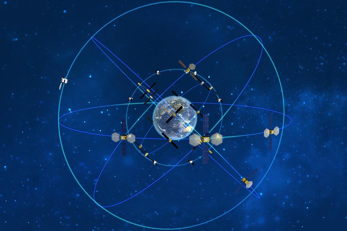
BDS-3 satellites are placed on 3 different types of orbits: geostationary (Beidou-G), inclined geo-synchronous orbit (Beidou-IGSO) and medium earth orbit (Beidou-M).
3 GEO satellites operating in orbit at an altitude of 35,786 km are located at 80°E, 110.5°E, and 140°E. 3 IGSO satellites operate in orbit at the same altitude and an inclination of the orbital planes of 55 degrees with reference to the equatorial plane. 24 MEO satellites are placed in orbit at an altitude of 21,528 km with the same inclination of the orbital planes as the IGSO satellites.
BDS-3 is configured to introduce new frequency bands: B1C / B1I / B1A (1575.42 MHz), B2a/B2b (1191.795 MHz), B3I / B3Q / B3A (1268.52 MHz), including the Bs test frequency (2492.028 MHz).
Being one of the Global Navigation Satellite Systems (GNSS) along with GPS (USA), GLONASS (Russia) and Galileo (EU), BeiDou is used to provide a large number of public and military services.
BeiDou Services
To date, the BeiDou satellite constellation is represented by 45 satellites: 15 BDS-2 satellites and 30 BDS-3 satellites operate in tandem, providing users with seven types of services.
Regional services are provided on the basis of geostationary orbit (GEO) satellites, and the global ones are medium earth orbit (MEO) satellite-based, which includes search and rescue (MEOSAR) service.
Global services provided by the system: positioning, navigation and timing; global short message communication; international search and rescue (SAR) service.
As for the positioning service, BeiDou provides it, like other GNSS, at two levels: open (public) and authorized (military). The accuracy achieved after upgrading the system performance in the third stage is 1 m for public use and 1 cm for restricted military use.
Additional services for the Asia-Pacific region are satellite-based augmentation; ground augmentation; precise point positioning; regional short message communication services.
A number of international organizations involved in standardization processes (the International Civil Aviation Organization (ICAO), the International Maritime Organization (IMO), Cospas-Sarsat and others) have ratified the BDS. Many international standards have also been developed to support BDS.
Comprehensive work is being carried out by BeiDou to ensure compatibility and interoperability with other GNSS providers.
BeiDou Search and Rescue Service
One of the most important applications of GNSS systems is the provision of search and rescue (SAR) service. All GNSS are part of the common Cospas-Sarsat system, which determines the location of the signal from the activated distress beacon and transmits it to the processing center, which forwards the data to local rescue services.
The BDS search and rescue service is developed in accordance with Cospas-Sarsat standards. It includes MEOSAR service provided by MEO satellites, as well as a B2b signal-based Return Link Service (RLS) provided by MEO and IGSO satellites.
To provide MEOSAR service, BeiDou has equipped 6 of its MEO satellites with the Cospas-Sarsat SAR payloads. If everything goes as planned, the work on integrating these elements into the Cospas-Sarsat system will be completed this year.
The operation of the RLS service is provided by 24 MEO satellites and 3 IGSO satellites, which have already passed the necessary verification and are at the stage of coordination within the Cospas-Sarsat system.
To understand the features of the SAR service provided by BeiDou, let's remember how the traditional 406 MHz satellite SAR service functions.
Such a service provides one-way communication from the user in distress to SAR authorities. The activated radio beacon transmits at 406 MHz an alert signal to the SAR payload of the satellite, which is part of the Cospas-Sarsat system. Then the signal is forwarded from the satellite to the ground segment responsible for taking the necessary rescue measures.
The BDS SAR service provides the possibility of two-way communication for search and rescue. Its component, BDS return link service (RLS), allows SAR authorities to send to the beacon a return link message (RLM) with plain text information. In this way a user in distress will receive a confirmation that his/her request has been received, or information related to SAR progress.
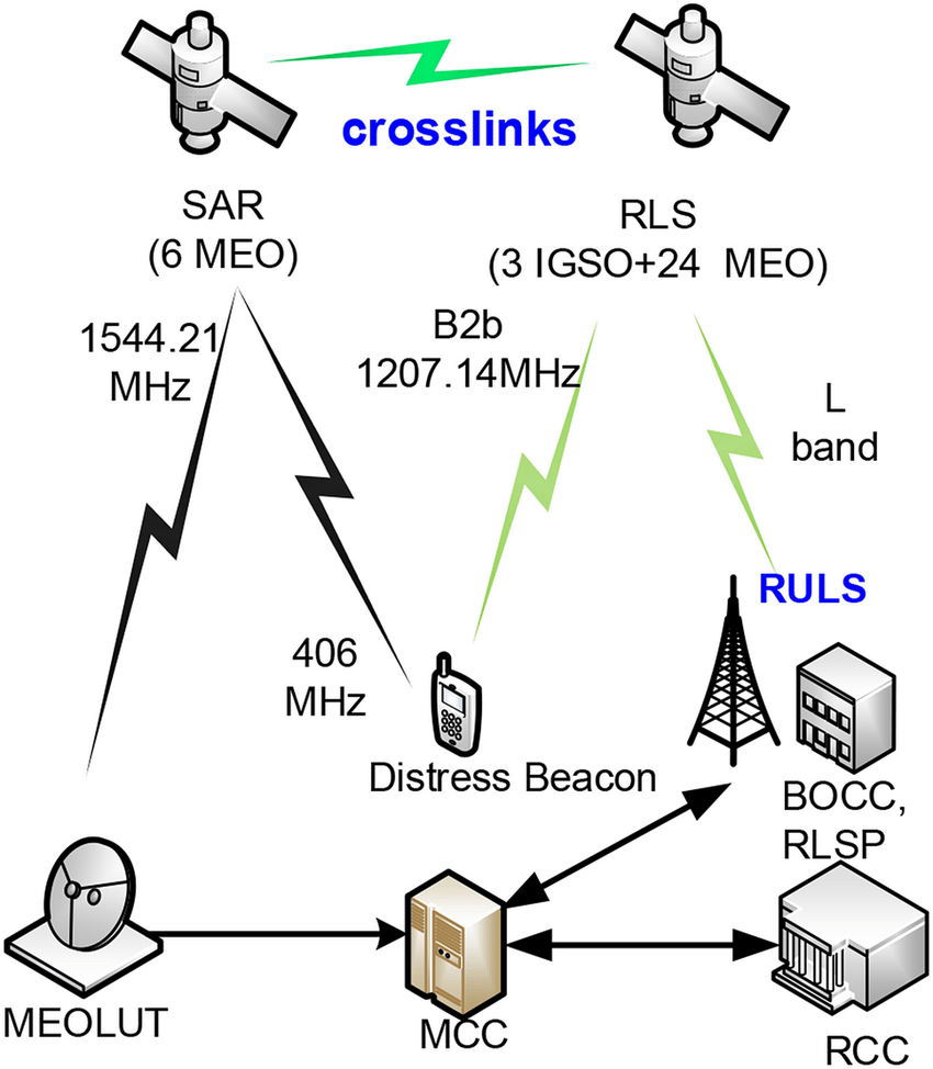
BDS SAR and RLS components. Photo source: https://www.researchgate.net
BDS RLS is currently being tested. For this purpose, a special Cospas-Sarsat beacon with BDS RLS has been designed. The key feature of such a beacon is the reception and processing of BDS RLM.
The tests demonstrated the efficiency of the BDS RLS architecture: the RLS time delay was less than 2 min (for comparison, the same indicator in Galileo RLS is about 15 minutes).
BDS can provide SAR service to all users on the Earth's surface, as well as in areas extending 50 kilometers above it. It will operate with two types of beacons: the first-generation beacon and the second-generation beacon, designed according to Cospas-Sarsat documents T.001 Specification for Cospas-Sarsat 406 MHz Distress Beacons and T.018 Specification for Second-Generation Cospas-Sarsat 406-MHz Distress Beacons, respectively.
According to the preliminary tests, the BDS MEOSAR, RLS and positioning services provide the probability of detection by the Cospas-Sarsat system of about 99%.
BeiDou Message Service System
In 2020, the International Mobile Satellite Organization (IMSO) signed an Agreement to assess the BeiDou Message Service System (BDMSS) for use in the GMDSS.
The system capabilities include a short-burst data service mechanism, ship-to-shore, shore-to-ship and ship-to-ship alarm and short messages, with four levels of priorities, providing distress alarm, emergency, safety and routine communications for maritime users. The optimal short-burst data response can be completed in one second.
High availability of BDMSS service is ensured by the fact that in most cases user terminals are under the coverage of numerous BDMSS satellites. Being designed with omnidirectional antennas, BDMSS terminals provide reliable operation in a harsh environment, for example, at sea, or in case of single satellite failure.
Currently, the technical and operational capabilities of this messaging system are being evaluated for compliance with the criteria set out in IMO resolution A 1001(25) on Criteria for the Provision of the Satellite Communication Systems in the GMDSS. BDMSS has already received a satisfactory assessment on the network availability criterion of at least 99.9%, as defined in the resolution.
Initially, BDMSS system provided maritime security services for ships navigating in the Asia-Pacific region. In 2020, after upgrading, it made the transition to full global coverage.
The BDMSS global system is built on the principle of its full compatibility with its existing terminal products and services. The design of GMDSS terminals based on BDMSS is carried out jointly with manufacturers of equipment for maritime communications. Particular attention is paid to ensuring the integration of this equipment with other shipborne GMDSS systems currently in use.
BDMSS is also developing an integrated Maritime Safety Information (MSI) broadcasting system and intends to integrate GMDSS services with Rescue Coordination Centers (RCCs) and MSI suppliers. A special test platform will be built to verify the success of this integration.
Conclusion
The satellite industry is evolving, and following it, GMDSS is also being modified - the course is taken to transition to a multi-provider environment. After the integration of the Iridium satellite system in 2020, another applicant to provide satellite services for GMDSS appeared on the horizon - China’s BeiDou.
This is a strong claim. The construction of the BeiDou system has already been completed, and most of the services are available. The conducted preliminary tests demonstrate that the BeiDou components declared for use in the GMDSS meet the requirements of this system. So, with a high probability, we can say that the recognition of BeiDou as a provider of GMDSS satellite services is not a matter of much time.
By Olga Davydova
References:
http://www.beidou.gov.cn/xt/gfxz/202105/P020210526216231136238.pdf
https://equalocean.com/analysis/2020082614631
https://en.wikipedia.org/wiki/BeiDou
https://imso.org/2020/07/02/imso-signs-agreement-to-assess-beidou-message-service-system-%E2%80%8B/
https://satellite-navigation.springeropen.com/articles/10.1186/s43020-020-00025-9
http://www.beidou.gov.cn/xt/gfxz/202008/P020200803362068698004.pdf
https://www.gpsworld.com/directions-2021-bds-marches-to-new-era-of-global-services/
https://iopscience.iop.org/article/10.1088/1742-6596/1995/1/012051/pdf


Be the first to comment